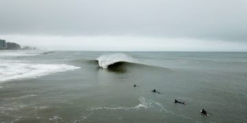


Good-Epic: Alabama, December 22. Photo: Alex Dantin
We love waves around here. Shocking. They’re what get us up in the morning and what we think about before we go to sleep at night. We love all kinds of waves, actually, but perfect, empty waves tend to grab our attention the most. Hence our ongoing Good-Epic series, which is below, for our mindsurfing pleasure.
Above pic: “I guess if any of these get published, Alabama will be the new surfing Mecca of the South,” laughed Florida photog Alex Dantin. “We honestly didn’t think we would ever see Alabama as good as we did on October 19, ’19. But when we woke up on Sunday morning, we couldn’t believe what the buoys were reading. Round two? No way. Is it possible the heart of Dixie would produce again? We knew our (FLA Gulf) sandbars were not going to hold anything with readings like that, so we loaded up and made the familiar drive over the state line with hopes of striking gold, again. It was rainy, cold, and wet out this time, but that certainly did not put a damper on the stoke as we walked over the dune and saw overhead drainers. Was this real life or just fantasy? It was live action deja vu . Another day for the history books, that’s for sure, as the solid swell pumped all day with offshores.”
Good-Epic? Know before you go.
Surfline’s Charlie Hutcherson explains further: “A trough moved east across the Gulf of Mexico on Saturday, developing a center of low pressure and intensifying into Sunday before heading off to the Atlantic. The key to the firing surf in Alabama and parts of the Florida Panhandle over the weekend was the storm’s slow movement. This allowed the perfect set up for the Gulf — an all-day, open tap for swell and steady offshore winds. As the storm intensified, gale force southeast winds developed just offshore on the front side of the storm and were perfectly aimed backed at those zones. And since they were located to the west of the storm’s center, they saw breezy offshore northerly winds all day, completing the perfect pre-holiday combo. In the Gulf, all too often the swell source (storm) quickly exits and any offshore winds quickly beat down the remaining surf. Not this time, the storm hung around for the day and the winds weren’t enough to drive old Dixie’s overhead surf down.
SWELL SIGNATURE
Storm Location/Movement: Trough moved east across Gulf before low pressure developed and intensified near Florida Panhandle into Sunday. Slow movement through the region kept swell producing wind over water and offshore winds over land for part of the region.
Strongest Storm Wind: Gale force as identified by the Ocean Prediction Center.
Peak Seas: 14’ seas measured on Sunday at the Pensacola buoy (#42039)
Swell Travel Time: Six to 12 hours
Swell Height, Period, and Direction: 8-9 feet at 10 seconds from the southeast at the Orange Beach, AL buoy (#42012)
************
Good-Epic: Eastern Canada, December 11th
Freezing, heaving peaks detonate for a small crew of locals and visitors

Photo: Scotty Sherin
As we’ve been noting the Atlantic Ocean has been busy. The best spots have been on the colder side, but hey. Case in point, last week, Canadian photog Scotty Sherin scored a few special sessions near home. “Rob Kelly, Robbie Goodwin, Ryan Huckabee, and local charger Logan MacLennan were trading off on bombs,” he said. “The weather was wild: it was raining super hard in the morning, then changed to snow. I was freaking out because my camera was skitzing out from all the wetness — but the waves were firing, so I had to keep shooting. Trying to find focus through the rain and snow was another problem altogether. The final tally? Four surfers, three broken boards, one questionable ruined camera — but totally worth it!”
Good-Epic? Know before you go.
“On December 9th, low pressure came together over the Midwest US and tracked past the Great Lakes and through Eastern Canada on the 10th,” explained Surfline forecaster Rob Mitstifer. “Interestingly, this low on its own was pretty pedestrian, as this pattern occurs several, if not dozens of times, each year. However, the special sauce in this case was robust Atlantic high pressure, which we have mentioned has been a primary cog in the Atlantic wave machine recently. The low bottomed out at 983 millibars while the high peaked at 1044 millibars, setting up a respectable 61 millibar pressure difference between the two features. The resulting south to south-southwest fetch between the system’s cold front and the offshore high was aimed directly at Nova Scotia, which delivered a strong shot of mid-period swell on December 11th. At the same time, the cold front cleared the Canadian Maritimes in the early morning hours of the 11th, dropping air temperatures below freezing while also setting up favorable local winds.”

LOLA
SWELL SIGNATURE
Storm Location/Movement: Low pressure tracked from the Central US and Great Lakes region northeastward through Eastern Canada on December 9th and 10th. This low was just one piece of the puzzle though, as an anomalously strong high pressure system over the Central Atlantic aided in intensifying the pressure gradient and resulting fetch over the western Atlantic.
Strongest Storm Wind: Large southerly fetch of at least 30 knots with peak wind speeds nearing 50 knots
Peak Seas: Satellite confirmed 23-foot seas but potentially larger seas that went unobserved
Swell Travel Time: Eight to 24 hours
Swell Height, Period, and Direction: 18.3 feet at 11 seconds from the SSW (201 degrees) on Georges Bank buoy (44011).
************
Good-Epic: Los Angeles, December 2nd
Solid, nearby, and reasonably west swell lights up SoCal

Photo: Fred Pompermayer
Nothing arouses the sensibilities of switched-on, wintertime SoCal surfers quite like a nearby low pressure system sending a pretty westerly west-northwest swell. Typically fun and occasionally pumping, nearby storms often open up whole swaths of the coast. The resultant broad-angled swell mixes are a boon for beachbreaks — especially places like the South Bay, where closeouts are generally just masquerading as makeable. But with a series of nearby storms, the last couple weeks have been special here — as in two good-to-epics in as many weeks special.
Good-Epic? Know before you go.
Our Thanksgiving low set the stage for this installment, allowing a developing storm near the Aleutians to spin off a second low which dropped southeastward on Black Friday. This storm intensified overnight, reaching peak intensity about 1000 miles off the West Coast on Saturday morning. Satellite readings depicted a respectable pocket of 40- to 45-knot+ winds and seas in excess of 35 feet. Game on. The low then sagged a little further south and stalled out, setting up perfect conditions starting Sunday and still going now. –Schaler Perry
LOLA.
SWELL SIGNATURE
Storm Location and Track: Developed below Gulf of Alaska, reaching peak intensity while dropping southeast towards SoCal
Storm Wind: Respectable pocket of 40- to 45-knot+ winds
Storm Seas: Satellite confirmed seas of 35 feet
Swell Travel Time to SoCal: 1.5-2 days
************
Good-Epic: Remote Indonesia
P-Pass meets J-Bay meets Rifles — all for an audience of one, October 26th
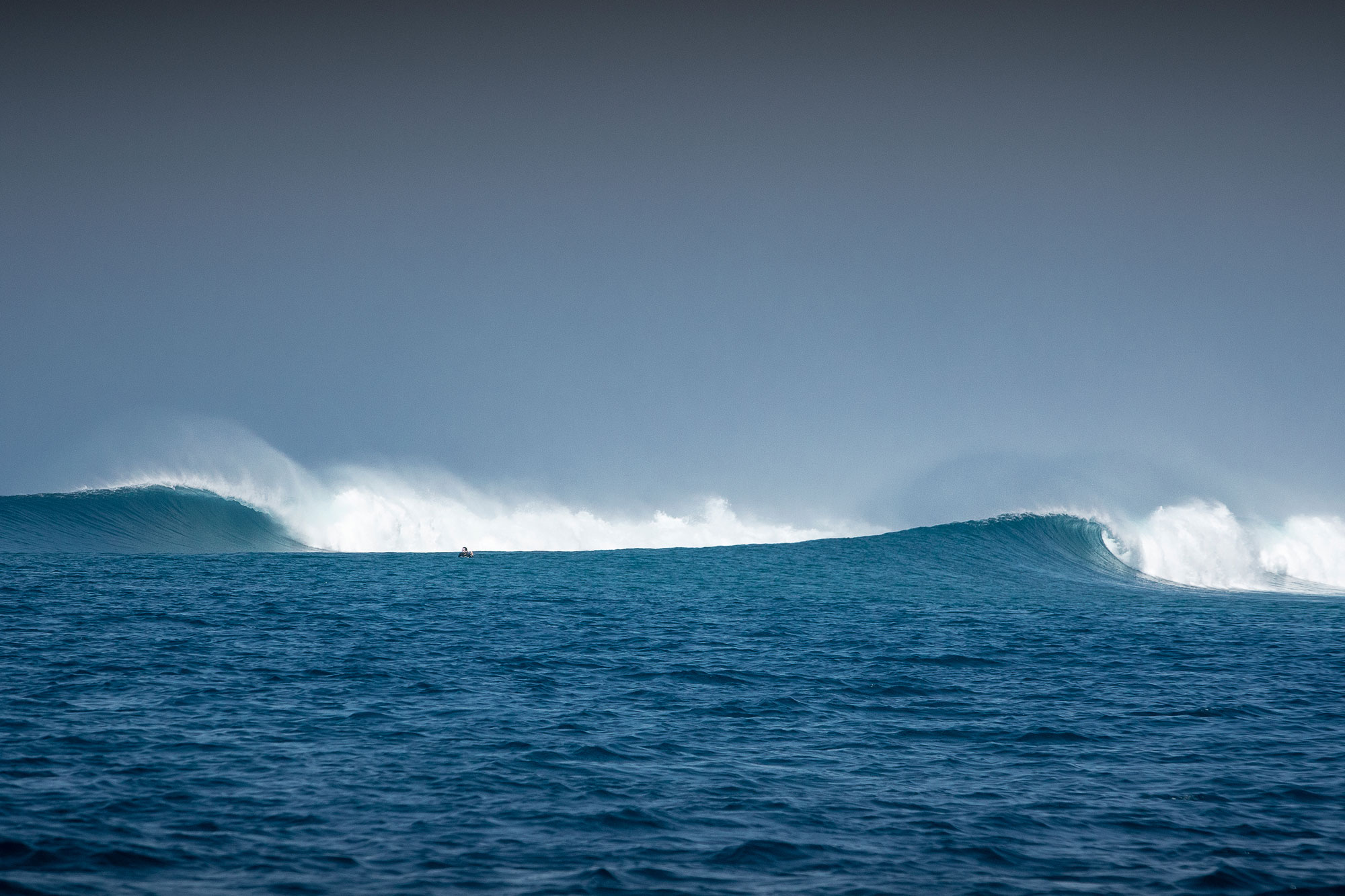
Photo: Federico Vanno/Liquid Barrel
No, this dreamscape freight-train ain’t the Mentawais. Or anywhere near the madness of Bali. Head East, young person. Way east. “I love traveling and discovering new waves,” says Indo-based photographer Frederico Vanno. “The Nusa Tengara region is best in the dry season, between May and October — and the end of the 2019 season saw all kinds of swell, with light winds every day and only a few people around. In one day, we surfed three different waves. Thanks to a speedboat, our movements were much faster and more comfortable than a regular boat, and after noticing a change in wind direction, we moved to another side of another island. And magically, we found ourselves in front of a long, pointbreak-righthander far from the island coast — and waves like highways…”
Know before you go
************
Good-Epic: Central Florida, Hurricane Dorian
Perfection in Dorian’s rearview, September 4th

Photo: Nate Harrington
We have been tracking Hurricane Dorian in realtime since August 28th. It devastated parts of the Bahamas (here’s one way to help) and largely spared Florida, providing a few windows of a few memorable moments of surf. “On Wednesday morning, my backyard looked like a world-class surf destination as Hurricane Dorian jetted up and away,” said Central Florida photog Nate Harrington. “We got a short round of surf — and it sure was good. That immediate north swell with hard west winds perfectly groomed out central Florida and there was barely even yard work to keep me from it. Prayers, dreams, it all came true for us in Florida. That said, I’m exhausted from this storm and more than ready to see it disappear up off the coast. Praying for friends in the Outer Banks of North Carolina as this approaches them and sending my prayers and thoughts to the people of the Bahamas.”
Watch: Hurricane Dorian Live Stream
Realtime Updates: Hurricane Dorian Storm Feed
************
Good-Epic: Sumbawa, August 25
And Indo’s dream run continues

Photo: Trevor Murphy
Surf spot names are funny things. Sometimes, they’re named after location. (Here’s looking at you, 56th Street.) Sometimes, after the people who discovered ’em. (Hey there Lance’s Right!) Oftentimes, after a local landmark (Don’t forget Lighthouse!) And sometimes, like in the case above, they’re named for what they’re capable of. Welcome to Scar Reef, in Sumbawa, a fickle, perfect, hollow — and shallow — left tube in a land of left tubes. No question what happens if you fall here. “2019 has been an incredible year for surf,” says globetrotting photog Trevor Murphy. “Indonesia particularly has been all time for months now. Case in point: These two happy travelers, star struck in Sumbawa.”
We tapped Surfline Lead Forecaster Jonathan Warren for details: “The southern half of the Indian Ocean saw a very massive storm system that rummaged very slowly across the basin from the 15th through the 21st,” he said. “Although this storm was at its strongest way back when it first stepped out from under Africa and into the Southwest Indian Ocean – around the 16th with a very impressive 50-60kts and seas of 50-55 feet — it continued to maintain a very large and strong fetch aimed at Indonesia for the following several days. The longevity of this behemoth storm was helped along by a series of other lows that continued to feed the storm, as they popped out from under Africa and were absorbed by it. Furthermore, strong high pressure ridging in behind the storm not only assisted with developing strong storm winds, but it helped to direct a well-aimed fetch toward Indo as well. The end result was an immense purple blob that propagated across the Indian Ocean to surfing’s Disneyland.” (And yeah, there’s more on the way.)
Premium: The Mentawais Five Best Surf Weeks of the Year
Try Surfline Premium For Free
*The good folks at Waterways Travel have Sumbawa options right here.
************
Good-Epic: Kandui, July 10th
Restaurants comes to the Mentawais
Photo: Kandui Resort
No, this is not Restaurants. (Though you could’ve fooled us.) Turns out, when the swell’s south enough, and shorter period, the normally near-unmakeable lefts at Kanduis turn into something resembling every goofyfooter’s dream wave, which happened on July 10th. And of course, it being July, there’s more swell on the way.
The good folks at Waterways Travel offer a half dozen options in the region — from boat trips in the Mentawais to land camps at Kandui, Macaronis and the Telos. Take a spin through their various regional offerings .
************
Good-Epic: Bali, June 11
Island of the Gods offers three enticing reasons to book a trip
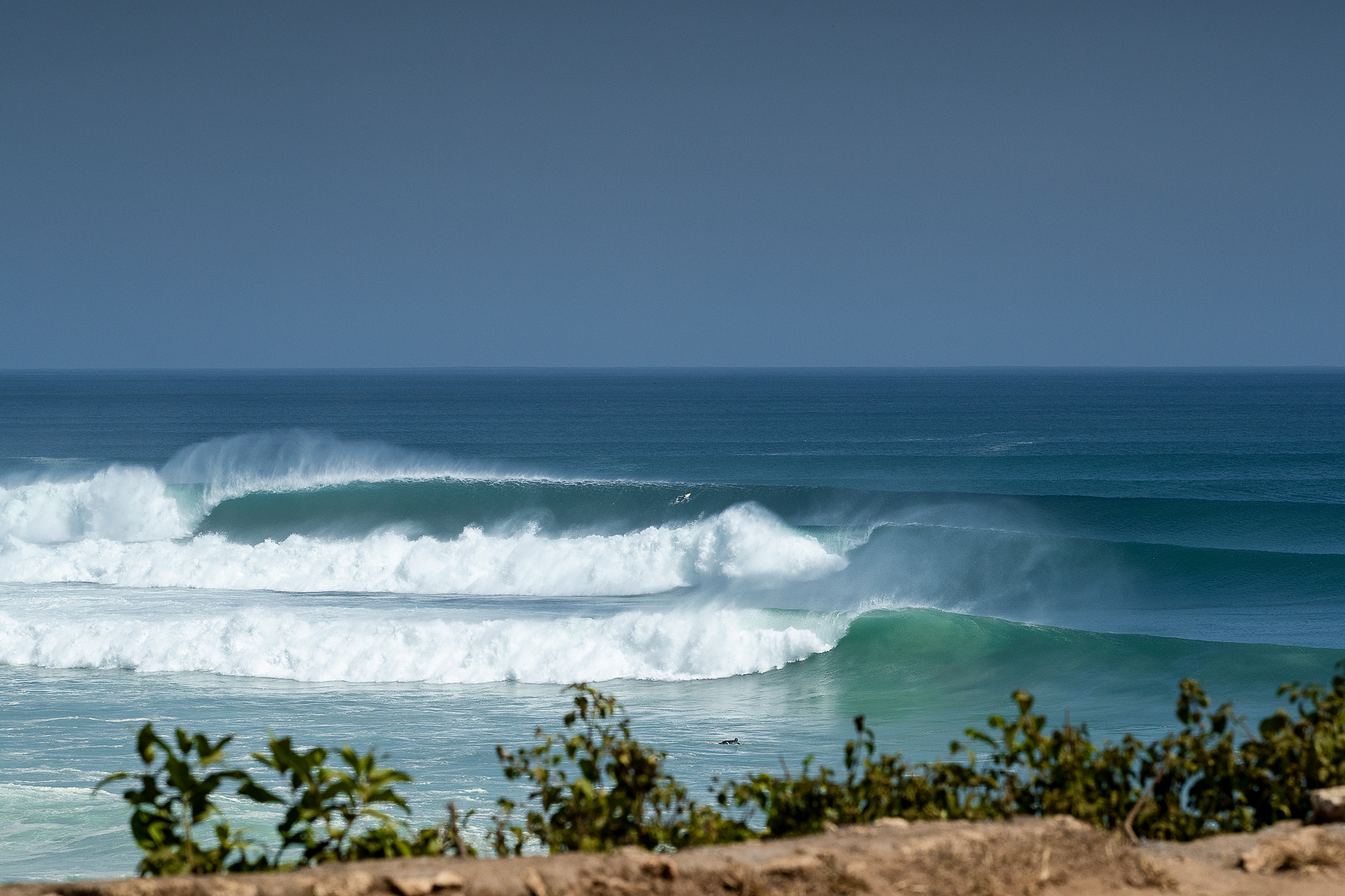
Photo: Federico Vanno/Liquid Barrel
The Island of Bali has never heard of June Gloom. Generally, this is a month of celebration, with consistent Indian Ocean swells, dependable offshore tradewinds on the west coast and clear, all-day sunshine. Yesterday was a fine example, as seen above here at one of the island’s slightly less marquee spots. “This storm had all the ingredients in place to bake up a solid swell for Bali,” explained Surfline Forecaster Mike Watson. “It developed behind an earlier system, so it already had an agitated sea-state to build upon, the track was favorable, a strong 1038mb high pressure was located on the west side of the storm — and the storm was fairly close to the region.” Bake all that at 200 degrees and out pops a Good-Epic.
************
Good-Epic: La Punta, Puerto Escondido, June 4th
Goofyfoots, rejoice
Photo: Lucano Hinkle
The beachbreak at Puerto Escondido is mostly for closeout tube masochists. And normally, the semi-mushy left point (“La Punta”) south of town is mostly for surfers either sick of getting pummeled or who have no desire to get pummeled in the first place. This year, though, an abundance of rain helped form the sandbar into something resembling good-epic. “It was lots of water,” said Puerto-based photog Lucano Hinkle. “Like 13.3 inches in a week — and we had one night where it rained 5.4 inches. All that rain moved around a bunch of sand and the surf got way better at La Punta.”
And this is just the cherry on top. “Coming off a great May, the hits keep pouring in from the South Pacific,” explains Surfline forecaster Schaler Perry. “Though this good-epic day landed in June, the swell came from late May as a series of impressive lows tracked from the south of French Polynesia across the central South Pacific. As with many of these special days, the storm system sending the swell followed directly behind a preceding storm and was flanked by a respectable area of high pressure as it peaked in intensity on May 27th.”
View: Live Puerto Escondido Cam
“While not as strong as several of the storms we saw earlier in May, the system was advantageous the sea state left behind by the preceding storm (preheated oven) to the tune of satellite measured seas reaching 35 feet along with a modest pocket of 40- to 50-knot winds. The grease to the wheels coming by way of impeccable local conditions thanks to the return of more typical afternoon storms and stiff offshore morning winds for the Puerto Escondido region.”
**Check out Waterways Mexico Surf Travel Options right here.
*********************
Good-Epic: Huntington Beach (!?), May 22nd, 2019
Because sometimes, perfection is closer than you think
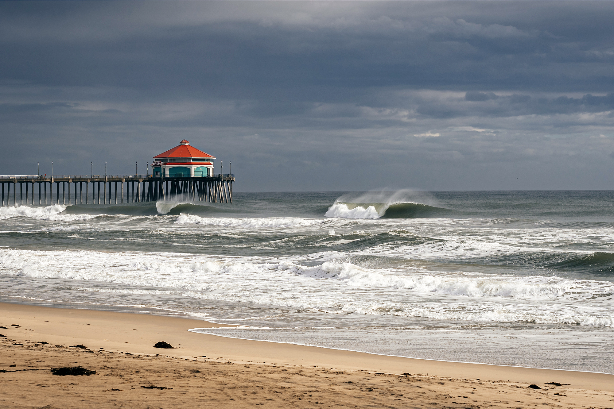
Photo: Keaton Browning
We’ve been doing this whole Good-Epic series showcasing perfect lineup photos since about 2011. Mostly, as you’d expect, it’s places like Cloudbreak or the Mentawais or Maldives or some other dreamy tropical spot. ‘Cause lets face it: they tend more towards Good-Epic than say, the average beachbreak down the street.
Well, in Wednesday afternoon’s case, the average beachbreak directly across the street from Surfline HQ decided to show up and throw its hat into the ring with a few-hour window of absolutely flawless, punchy, offshore a-frames. It got very difficult to focus in meetings when it looked like the Outer Banks or Ocean Beach or Hossegor out front. And PS: This never happens. Especially in the afternoon, and especially on an afternoon in May, which normally sees whitecaps to the horizon with the typical spring northwest winds. We grabbed forecaster Schaler Perry after he got out of the water with salt-crusted eyebrows and an unshakeable, wide-eyed grin.
“The South Pacific has had the hot hand for the last few weeks while the North Pacific has been seasonably slowing,” he said. “That said, the basin has offered up a swan song over the last week, peppering California with uncharacteristically strong May storms bringing rain/mountain snow, an abundance of onshore winds, and fairly solid NW swell (hey, even Mav’s was breaking the other day). And while the North Pacific has been unseasonably active, the South Pacific has stayed busy and sent a healthy south swell to mix with the barrage of northwest swells this week.
“There have most certainly been some windows of opportunity for the resourceful this week, but Wednesday late afternoon and evening provided a couple hours of surf as good as it gets for North Orange County beachbreaks. Further, the confluence of events that led to the golden window of surf was remarkable. Healthy south swell isn’t unlikely in May. But to also have overhead northwest waves — and a window of moderate offshore winds following the passage of a squall line? That doesn’t happen too often around here, and rightly garnered flashes to the East Coast’s ability to go from a two to a ten in the blink of an eye.”
NPAC Storm
Location and Track: On May 19th a respectable storm develops north of Hawaii on a track towards the West Coast, eventually moving through SoCal Tuesday the 21st.
Storm Wind: Modest area of 30-40 knot wind below Gulf of Alaska, widespread 20-30kts+ winds extending through the Southern California bight on Tuesday adding-shorter period swell.
Storm Seas: Satellite confirmed seas of 25 feet below Gulf of Alaska, mixing with local shorter-period swell the NW energy was over 9 feet on the San Pedro buoy (18 miles from HB).
Swell Travel Time to Southern California: One-three days.
More Coming? View: North Orange County Premium Analysis
*********************
Good-Epic: Lance’s Right, April 25th
Crown jewel of the Mentawais shines

Photo: Trevor Murphy
A surf spot with two names…Lance’s Right is named after Lance Knight, a feral adventurer who discovered the wave in 1991. A couple weeks later, the Indies Trader showed up, and captain Martin Daly named the wave after Lance. It’s also called Hollow Trees because, you guessed it, there was a very hollow tree in front of the lineup. These days, the names are used interchangeably, but the one thing that hasn’t changed is the sheer perfection of this challenging right tube. And as Indo has been pumping nearly nonstop for weeks, it’s no surprise that some of the best waves in the archipelago were seen and ridden here. (Plus, photog Trevor Murphy’s capture is beyond what anyone’s ever doodled on their schoolbooks.)
We asked Surfline forecaster Schaler Perry about this particular slice of perfection. “The higher latitudes of the South Indian Ocean — arguably the most potent area for swell-making on the planet — were in full swing through April,” he said. “This is good news for places like the Mentawais, which entertained an elongated run of well overhead surf through the back half of April as the basin went to an 11. The glassy, well-overhead bookend to the run was courtesy a large area of low pressure which strengthened while sliding out from under South Africa Wednesday the 17th. The impressive low peaked in intensity by Friday the 19th at 939mb and was complimented by an adjacent 1027mb area of high pressure. Seas scraping 40 feet were measured by satellite roughly 3500 miles – five-six days travel time – away.”
View: Premium Analysis for Mentawais
***
The good folks at Waterways Travel offer a half dozen options in the region — from boat trips in the Mentawais to land camps at Kandui, Macaronis and the Telos. Take a spin through their various regional offerings right here.
*********************
Good-Epic, Video Edition: Nias, April 19, 2019
How good is Lagundri Bay’s famed right tube?
Nias, the beautiful, iconic right tube tucked inside Lagundri Bay, was most recently in the spotlight for scaring the heck out of some of the planet’s best barrel riders and catapulting a boat over the falls during last year’s Indo mega-swell. This is mainly because people love watching things crash. But the thing is, on a decent, human-sized swell — like the one that just graced Indo’s shores late last week — Nias is actually one of the friendliest tubes around, as illustrated by the Good-Epic video above. An average surfer with a decent step-up and a modicum of confidence can get the barrels of his or her life here. Plus there’s a channel, unlike many of Indo’s other famed waves that grow and speed up until detonating on dry reef.
We asked Kevin Wallis, Surfline’s Director of Forecasting, about this particular slice of Good to Epic. “While this wasn’t a monster storm by Indian Ocean standards it packed a pretty good punch and took a favorable track toward Indonesia for a period of two-three days,” he said. “The resulting swell was the season opener for the archipelago with relatively solid surf and generally favorable wind. There is more on the way, too, with the Indian Ocean moving toward peak storm/swell season and a number of medium size swells lining up in the next seven to 10 days. Another interesting feature we’ll have an eye on is a potential tropical cyclone that could deliver a rare angled west swell to parts of northern Indonesia over the weekend.” Vid: Justin Buulolo
***
Nias, of course, is not the only amazing wave in this part of the world. The good folks at Waterways Travel understand this, and offer a half dozen options in the region — from boat trips in the Mentawais to land camps at Kandui, Macaronis and the Telos. Take a spin through their various regional offerings right here.
*********************
Good-Epic: King Island Tasmania, April 9, 2019
Dreamy, wedgy a-frame beachbreak lights up

Martha Lavinia. Photo: Ed Sloane
Located in the Bass Strait between southwestern Australia and Tasmania, King Island is a remote and rural slab of land with less than 2,000 human residents and a sh*t ton of rare and endangered birds. It’s also home to one of the world’s best — and perhaps most fickle — beachbreaks, Martha Lavinia. Big swells wrap around the island from both directions, creating aquamarine blue teepees up and down the beach. Victoria-based photog Ed Sloane saw things lining up earlier this week, pulled the trigger on a quick surgical strike and scored. We asked Surfline’s Director of Forecasting Kevin Wallis why it got so Good-Epic. “A couple days into April a strong storm deepened in the Indian Ocean and tracked east-northeast through the Southern Ocean toward Tasmania, an area that is no stranger to intense autumn storms,” he said. “The resulting swell slammed into and wrapped around all sides of Tasmania’s King Island — just as high pressure and fair weather developed on April 9th.”
EXPLORE: Tasmania Surf Spot Map
KNOW BEFORE YOU GO: Tasmania Surf Forecast
*********************
Good-Epic: Perfect Restaurants From Above, April 4th
Waves don’t get much better than this
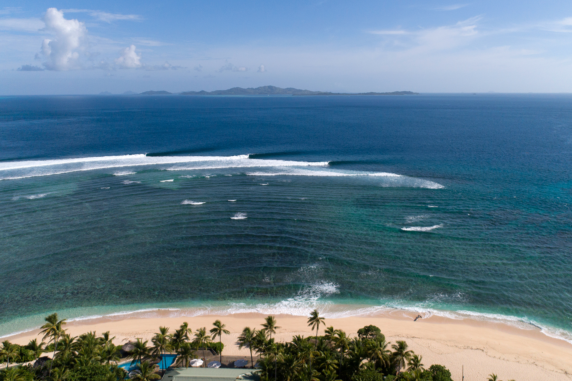
Photo: Scott Winer
Restaurants, the long, predictable, perfect reefbreak fringing the magical island of Tavarua is one of the top five lefts in the world, hands down. Surfline’s Jonathan Warren explains this particular magic day: “Restaurants tends to break best on mid-period and more westerly-angled SW swells, which was precisely the combination of the first pulse that moved in Thursday April 4th. To get this ideal setup, you need a fairly strong storm in the Tasman Sea, where a fetch of southwesterly wind develops off the coast of either Southeast Oz or Tasmania and cranks out swell toward Fiji. Furthermore, you want this storm to be fairly close, allowing for the bulk of the swell to be comprised of mid-period energy. (The pulse that moved in on the 5th was a little longer in period and a little more southerly in angle, which boded a little better for Cloudbreak.)
SWELL SIGNATURE
Storm Location/Movement: Pair of storms to the east and south of Tasmania over March 30th-31st.
Strongest Wind/Seas: Both storms up to 40-45kts+ and seas up to 30 feet+.
Peak Storm Intensity: Storm south of Tasmania (956mb) on the 30th. Storm east of Tasmania (984mb) on the 31st. Both flanked by 1024mb high pressure.
Swell Travel Time: Storm south of Tasmania (5.5-6 days) – peaked on the 5th. Storm from E of Tasmania (3.5-4 days) – peaked on the 4th.
Peak of Swell: Each estimated to be about four-five feet; first pulse 13-15 seconds from 225-215°, second pulse 15-16 seconds from 220-210°
*********************
Good-Epic: Dreamy New Zealand Beachbreak, April 1st
A brief celebration of one solitary, perfect peak
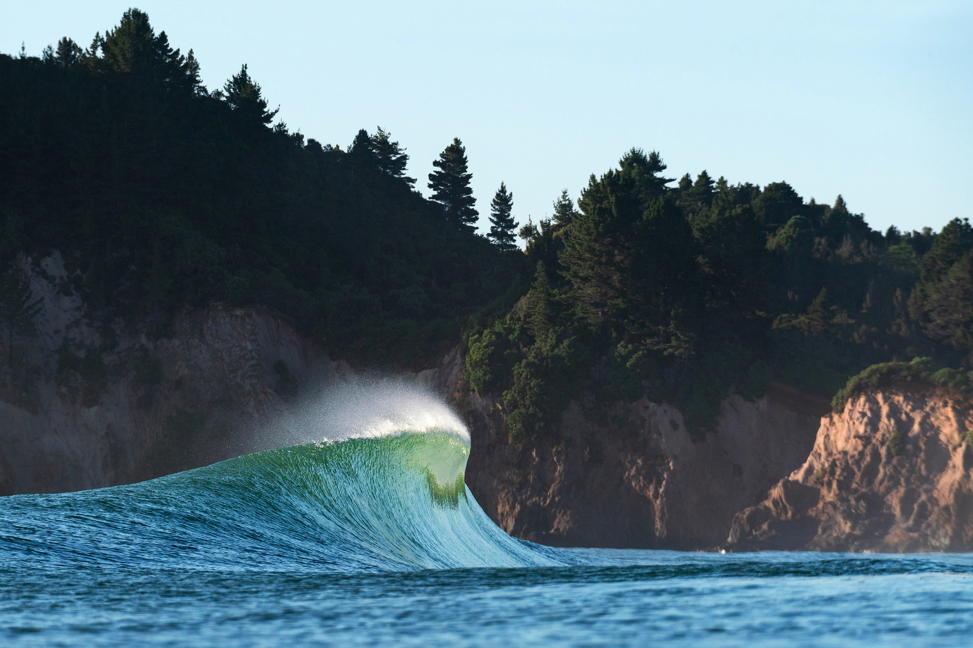
Photo: Rambo Estrada
Sometimes, as you’ll notice below, Good to Epic is a perfect, lined-up, well-known reefbreak. (Hello, Cloudbreak and P-Pass!) But sometimes, since so many surfers spend so much time chasing fickle sandbars at ever-shifting beachbreaks around the world, we feel obligated to share a particularly special sand-bottomed moment now and then. Case in point above, on the Coromandel Peninsula yesterday. It was just a morning swim for photog Rambo Estrada. “Not much of an exciting story, unfortunately,” he said. “We’ve had a seasonal long run of onshores and swell on the East Coast, but this day had a small window of offshore winds. As the swell was going to be a bit junky, I chose a beach that usually closes out for my morning session and it was producing fun peaks. The wind has just swung around onshore again — for the next two weeks.”
Read More on New Zealand: 10 Trips to Take With Your Non Surfing Better Half
*********************
Good-Epic: Cloudbreak Returns, March 12, 2019
A(nother) gentle reminder that the Southern Oceans are heating up

Photo: Scott Winer
The Southern Hemisphere is officially awake. Teahupoo got in on the action first, offering up a couple days of stellar surf for locals and visitors last week. This morning, Teahupoo’s longer Fijian cousin Cloudbreak offered up hours and hours of mindlessly glassy, endlessly perfect left tubes. One longtime, frequent Tavarua visitor said “it was as good as it gets,” and another got a little more specific, claiming “the best high tide Ledge I’ve ever seen.” Winds have been light for the past week, every day, almost all day, which may inspire more than a few goofyfoots to start researching flights and cleaning the wax off their stepups.
*********************
Good-Epic: Cape Town, February 21
Late summer groundswell meets offshore winds meets perfect sandbank

Photo: Anthony Fox
“It’s been a slow couple of weeks here in Cape Town, so to see this swell on the horizon was really exciting,” said local charger Frank Solomon. “And with the full moon and the spring tides, it was bound to be a good day of surfing here. The period felt pretty solid out there — must’ve been close to 16 seconds. When we arrived at the beach, it was hard to tell if the wind was southeast or a little too south, but we took the long walk down the sand anyway — and it paid off.”
*********************
Good-Epic: P-Pass, Micronesia, January 30
Oceania’s most famous right barrel comes alive, again

Photo: John Barber
Pohnpei’s Palikir Pass — P-Pass for short — way out there in the middle of the Pacific — is among the world’s most approachable right reefbreak tubes. The takeoff, unless giant, is kind of a roll-in. The tube section is very obvious and very wide and totally makeable. So basically, all one needs to do is be in the correct spot, make the drop, and go straight to get the tube of one’s life. We’re smack in the middle of the best time of year for this part of the Pacific — heck, we even named it as last month’s best bet — and there’s bound to be more on the way. (We even did a P-Pass v Lance’s Right in a Spot v Spot a few years back right here.)
*********************
Good-Epic: New England, January 25
A moment of perfection among Winter Storm Indrah
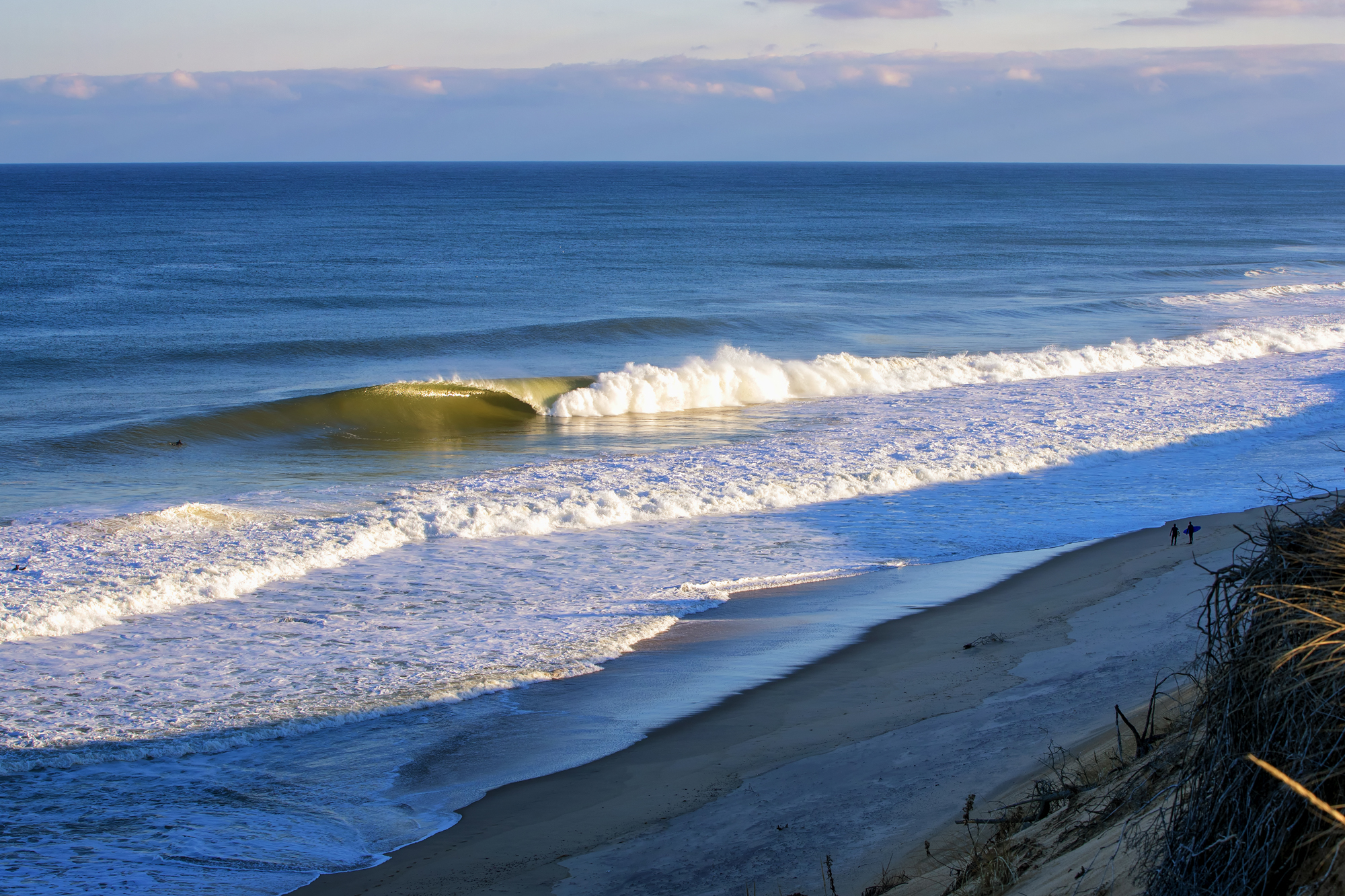
Photo: Trevor Murphy
Winter Storm Indrah was really, really mean to most places on the East Coast — subzero temperatures, sideways snow, bitter wind, etc. But a few tucked away places — like this New England beachbreak — had a few moments that made one want to get out of one’s snuggie.
*********************
Good-Epic: Pipeline: January 23
Another swell rolls into the Banzai
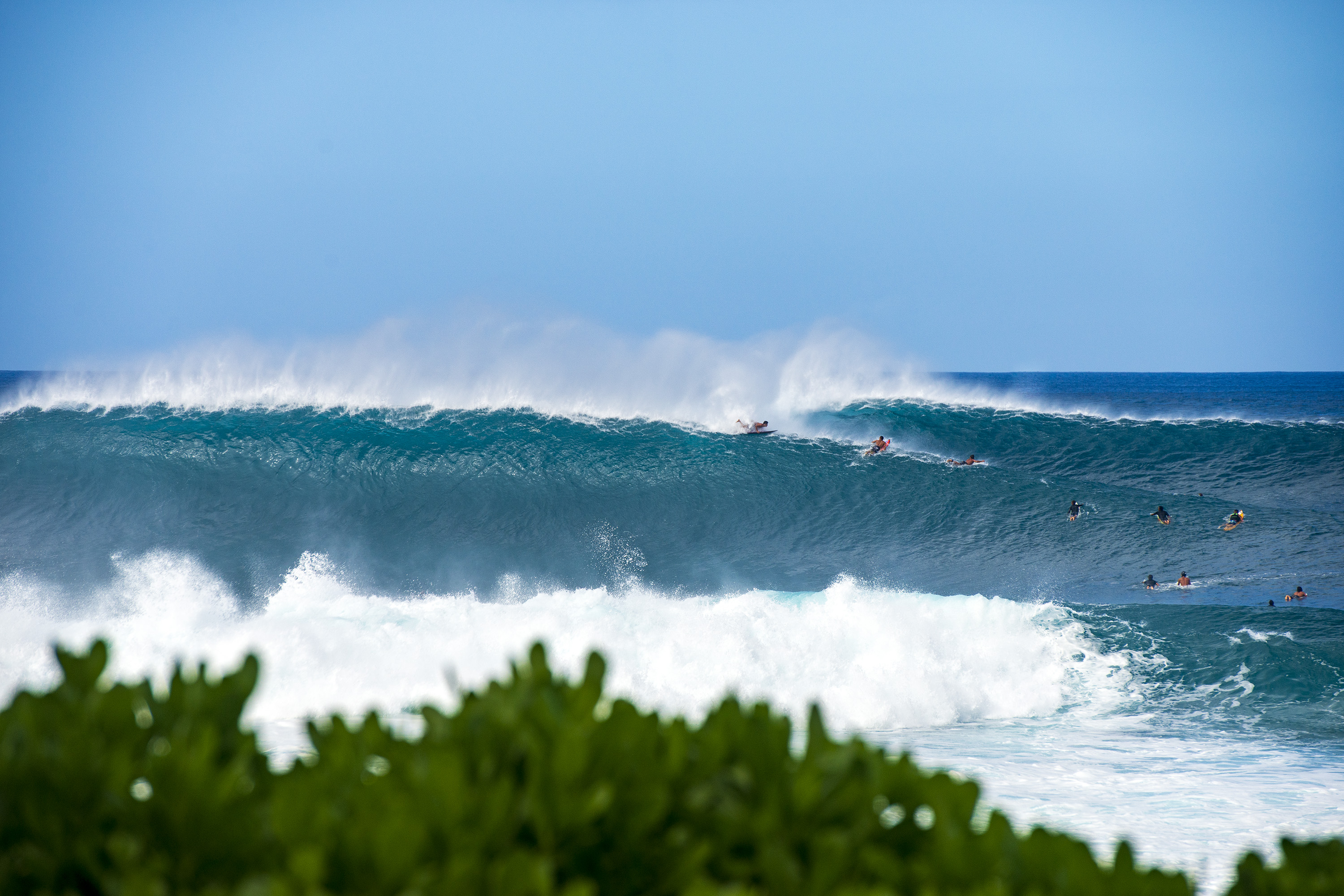
Photo: Pedro Gomes
Pipeline ended January much the way it began — by pumping relentlessly. North Shore surfers are almost — but not quite — surfed out at this point. “It was the best January in years,” said many. We did a cam rewind to celebrate.
SWELL SIGNATURE
Storm Location and Movement: Large, complex low pressure system with fetch extending off the Kamchatka Peninsula to within 1000 miles of Hawaii.
Peak Wind: Large area of satellite confirmed 30-40 knot wind, with isolated pockets to 50 knots.
Peak Seas: Satellite confirmed 35-40 feet.
Travel Time to the North Shore: three days.
Swell Height, Period and Direction: 8-9 feet at 16-17 seconds from the WNW (300-310 degrees) as measured by the Waimea buoy.


