


More than a year after a Peace Valley landslide forced the evacuation of Old Fort residents, with six homes still under an evacuation order or emergency alert, the regional district and B.C. government are wrangling over who is responsible for determining if the community of 200 is safe.
“This uncertainty is affecting the whole community down there,” Brad Sperling, chair of the Peace River Regional District, told The Narwhal.
“But even more so, the three [property owners] that are on alert, they’re living day to day being ready to get out. It’s not right and it’s not fair.”
The slide, in an area underlaid by numerous natural gas leases and near one entrance to the Site C dam worksite, was classified as a “dangerous occurrence” under B.C.’s health, safety and reclamation code.
That triggered a geotechnical assessment to identify “the root cause and contributing factors” of the slide, according to a briefing note for Peter Robb, mining and energy assistant deputy minister, that was included in the response to a Freedom of Information request made by The Narwhal.
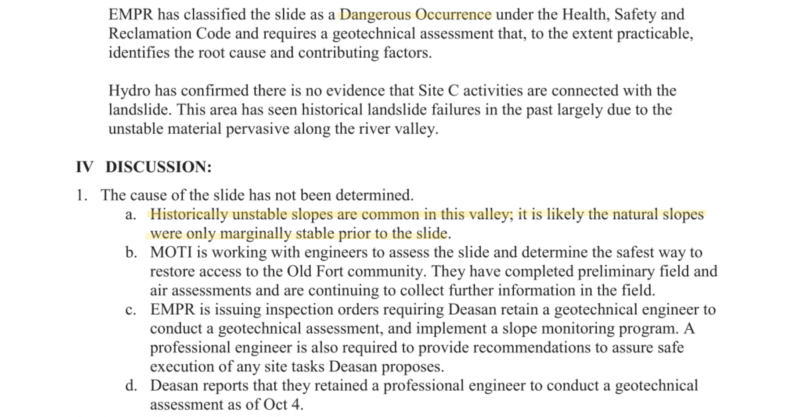
A screenshot of a briefing note prepared for Peter Robb, assistant deputy minister of B.C.’s Ministry of Energy, Mines and Petroleum Resources. The briefing note was obtained by The Narwhal through a Freedom of Information request. The document also notes the region is home to “historically unstable slopes.”
But almost 14 months later — with the landslide moving metres a day for the first month and then settling, before advancing another few centimetres last spring — the geotechnical assessment is not yet complete, the Ministry of Energy, Mines and Petroleum Resources said in an email to The Narwhal.
“The Chief Inspector’s investigation into this matter is ongoing,” the ministry said, noting that “13 months is not an unusual amount of time to complete such a complex investigation.”
“ … everything surrounding the slide is very hush-hush.”
The ministry did not respond to a question asking what information must still be gathered in order to conclude the investigation into the slide, which displaced eight million cubic metres of earth and blocked the only road to Old Fort for a month.
Old Fort resident Kali Chmelyk said community members are getting contradictory messages about the landslide, noting “everything surrounding the slide is very hush-hush.”
For example, when residents ask about the temporary road into the community and when it will be paved, they’re told the slide is still dangerous and still moving and not to stop their cars on the road because it isn’t safe, Chmelyk said.
“But then when you bring up ‘so it’s dangerous, what does that mean?’ Then you get the response of ‘oh no, everything’s fine, it’s not dangerous, it’s not moving anymore, there’s no danger to safety, blah, blah, blah.’ ”
“These are our homes and we want to know we’re safe where we are. I don’t want to be told in six months ‘it’s possible that this could happen again, so we’re just going to buy you out.’”

Google map showing the location of the Old Fort landslide in relation to the Peace River and the Site C dam. Photo: Cathrine Ruddell / Twitter
Site C project commissions landslide report
The banks of the Peace River are notoriously unstable, sparking calls for an independent safety review of the $10.7 billion Site C dam, the largest publicly funded infrastructure project in B.C.’s history.
Geotechnical problems have already slowed work on the project and have contributed to its escalating cost.
The Joint Review Panel that examined the Site C dam for the federal and provincial governments found that slope instability and landslides in the valley “would potentially adversely affect” the project and “could result in landslide-generated waves or overtopping of the dam that could result in direct damage to infrastructure.”
The FOI documents show that, immediately following the slide, BC Hydro requested a Site C project field reconnaissance report from BGC Engineering Inc.
Work being done to build a temporary access road to the community of Old Fort on October 20, 2018. Photo: Matt Preprost / Alaska Highway News
According to emails, BGC engineer Andrew Mitchell asked the provincial government for LIDAR data for a two-kilometre square area around the landslide. Other FOI documents show BGC examined LIDAR data dating back to 2015, the year preliminary construction for the Site C dam began.
“We’d be very interested in seeing the wider view of the recent topography,” Mitchell told the energy and mining ministry in an email.
LIDAR, which stands for Light Detection and Ranging, is a remote sensing method that uses lasers to record information about the earth’s surface. It is used for a wide range of land management and planning efforts, including for hazard assessment in the case of events such as tsunamis, lava flows and landslides.
Sperling said he wasn’t aware of the BGC report, which was sent to Pooley and others — including to staff in B.C.’s ministries of energy, transportation and forests, lands and natural resource operations — as well as to BC Hydro’s Site C team.
“They were doing LIDAR flyovers in that two-kilometre area but that was supposedly to figure out where the Old Fort slide was going,” Sperling said. “I had no idea that BC Hydro was involved in this.”
B.C. investigation into Old Fort landslide caught up in conflict of interest, residents say
Site C project landslide report redacted from FOI response
The BGC report was redacted from the FOI documents, which The Narwhal received more than one year after filing its request.
Almost 70 pages were removed from the FOI response on the grounds that contents would reveal policy advice or recommendations, or because disclosure would be harmful to law enforcement or personal privacy.
“Why are they redacting stuff?” Sperling asked.
Site C dam construction in 2018 along the banks of the Peace River. The dam is located roughly one kilometre upstream from the location of the Old Fort landslide. Photo: Garth Lenz / The Narwhal
He said he would ask the regional district board to write a letter to the provincial government at its next meeting on Nov. 28 requesting more information.
“We write letters, our MP writes letters, so does our MLA,” Sperling said. “And it just seems the province uses the wording in the [emergency program management] legislation and puts it back on the district and leaves us to our own devices.”
Gravel mine above Old Fort ‘not the root cause’ of landslide
According to emails in the FOI documents, a gravel mine stockpiling materials on the slope above Old Fort was not the root cause of the landslide, which destroyed a house and cut off the community with a wall of earth, rocks and trees.

Crews work to remove gravel loads from a pit above the Old Fort landslide, Oct. 6, 2018. Photo: Matt Preprost / Alaska Highway News
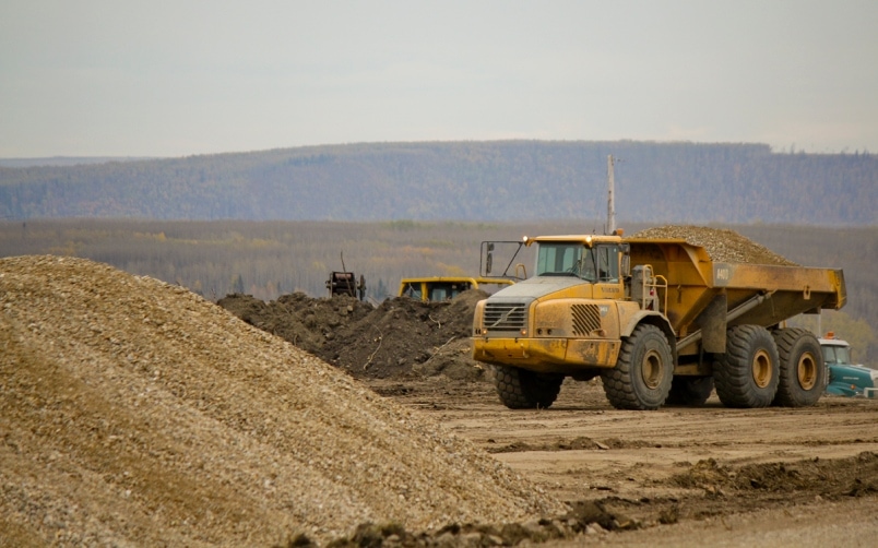
A load of gravel is moved away from the hillside and closer to the 240 Road. Photo: Matt Preprost / Alaska Highway News
“The size of the slide seems to indicate that there were underlying issues with the material down the entire slope,” said an email from mining inspector Adrian Pooley.
“The weight of the material is a contributing factor [to the] slide, but it is not the root cause,” Pooley, a professional engineer, wrote to senior inspector of mines Laurie Meade and others in the ministry.
The email was written on Oct. 2, 2018, just two days after the slide began, on the day Pooley toured the disaster area on the outskirts of Fort St. John.
Pooley also noted that the permit given to Deasan Holdings, owners of the gravel mining operation, stated that stockpiled material must be designed by a professional engineer “and when asked they said they had not done this.”
But “even if they had involved a geotechnical engineer it’s unlikely that they even would have identified the potential for a slide like this to happen,” Pooley wrote.
Sperling called the information about Deasan’s apparent non-compliance with its mining permit “surprising.”
The district had asked the provincial government if Deasan was in compliance with its permit, issued the month before the landslide, but did not receive an answer, Sperling noted.
“That is the kind of information that we’ve been waiting for,” he said. “We need to know what’s going on.”
Sperling said regional directors knew the ministry was investigating the potential role the gravel mine may have played in triggering the landslide. But he said they were not aware of the broader investigation into the root cause and contributing factors to the slide.
“My response is surprise. I didn’t know that. They’re doing a study on the root cause of it?”
Government says further landslide movement ‘is possible’
For months, the regional district and the provincial government have exchanged sometimes testy letters over who holds responsibility for determining if the slopes around Old Fort are stable enough for the evacuation order and alerts to be lifted. In addition to six houses, the order and alert include portions of other properties and Crown land.
“The vast majority of the evacuation order is actually on Crown land,” Sperling said. “That in itself frustrates us because now we are responsible for Crown land? If you read the emergency legislation we’re responsible for people and private land.”
In August, the regional district board asked Public Safety Minister Mike Farnworth for data and information to substantiate the minister’s claim that the area is unlikely to experience “a dramatic slippage of the remaining hillside that might further impact homes” in the Old Fort area.
A section of Old Fort Road, heavily damaged in the 2018 landslide. Photo: Matt Preprost / Alaska Highway News
The district informed Farnworth it will have that information “verified by geotechnical and all applicable experts.”
In response, deputy minister of Emergency Management BC Lori Halls wrote back that transportation ministry staff would reach out to ensure the regional district knows how to access data about earth movements.
“It is acknowledged that further slow movement of the terrain is possible, but as noted in the minister’s response, the assessment of the risk and application of evacuation orders or alerts is the purview of the PRRD [Peace River Regional District],” Halls said in a letter.
Sperling said the district has decided to commission its own geotechnical review of the current risk to properties in Old Fort, and the contract will be discussed at the regional board’s next meeting on Nov. 28. The district has requested funding from Emergency Management BC for the review, Sperling noted.
“We can’t wait,” he said. “It’s been 14 months. Those people want some clarity down there. And the board agreed to move forward even if we have to financially take it on ourselves.”

Old Fort resident Gord Pardy speaks at a community meeting, Oct. 6, 2018. Photo: Matt Preprost / Alaska Highway News

Old Fort residents at a community meeting. Photo: Matt Preprost / Alaska Highway News
Chmelyk said Old Fort residents are perturbed by the lack of information.
“It really seems that everybody is passing the buck and nobody wants to take responsibility and nobody wants to be held accountable for it — and that is super frustrating for all of us down here.”
Fish habitat work for Site C dam affected by slide
BC Hydro has said there is no indication the landslide was connected to nearby excavations and other major earthworks for the Site C dam.
However, the slide has affected at least one aspect of work on the hydro project, which is $2 billion over-budget and behind schedule for diverting the Peace River so the dam structure can be built.
Sperling said the landslide affected a Peace River island and blocked a back channel of the river near Old Fort where fish habitat enhancement for the Site C project was scheduled to take place.
“In order for them to go ahead with their original plans they would have to remove that part of the slide. Without proper assessment I would really object to that. I did have a meeting with them and said ‘I don’t want you guys touching that.’ ”
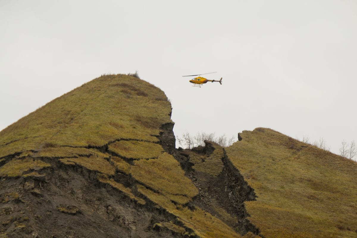
The Old Fort landslide began on September 20, 2018. In this photo, a helicopter takes a LIDAR survey to measure the landslide’s movement and speed on Oct. 6, 2018. Photo: Matt Preprost / Alaska Highway News
A Nov. 13 letter from BC Hydro to Sperling said “given the recent instability in the area” BC Hydro will not be initiating any work around Old Fort.
BC Hydro is “evaluating alternative locations to meet our commitments with the Department of Fisheries and Oceans,” said the letter from Shanna Mason, director of environment, regulation and community impacts and properties for the Site C project.
“BC Hydro understands and respects the concerns of the PRRD and Old Fort residents regarding any works which could impact slope stability,” Mason wrote.
DFO requires BC Hydro to implement “mitigation” measures as a condition of its environmental assessment certificate because the Site C dam will destroy fish habitat, including for at-risk bull trout, which will be anesthetized and transported past the dam in trucks so they can reach their spawning grounds.
BC Hydro does not intend to undertake works “in areas of stability concern and works within the Peace River mainstem near Old Fort are assessed by engineers to ensure there will be no interaction with the areas of instability,” Mason wrote.
She also said BC Hydro would brief the regional district and provide updates to Old Fort residents prior to completing any work on the north bank of the Peace River near Old Fort.
Gravel pit operator given new exploration permit
According to Michelle Mungall, Minister of Energy, Mines and Petroleum Resources, the investigation into the gravel mining operation’s potential role in the landslide was nearing completion last June.
In a June 12, 2019 letter to Sperling, Mungall said the scope of the investigation includes “determining the extent, if any, that the mining activity contributed to the landslide, reviewing the permitting process, reviewing the compliance history of the site and evaluating if there may be other sites in the province that should be reviewed for similar conditions.”
The FOI documents show that immediately following the slide, Victor Koyanagi, acting regional director for B.C.’s office of the chief inspector of mines, asked his staff for a list of “permitted aggregate pits located anywhere on the flank of the Peace River from Hudson’s Hope to the Alberta border.”
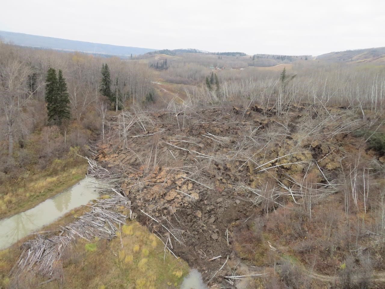
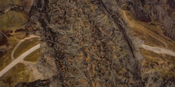
The Old Fort landslide took place in a region with historically unstable slopes. Photo: Matt Preprost / Alaska Highway News
That included all pits near the future Site C reservoir area, which will stretch 83 kilometres from Fort St. John to Hudson’s Hope, as well as an additional 45 kilometres, in total, along Peace River tributaries.
Aggregate, or gravel, is in high demand in northeast B.C. by the natural gas industry, which uses large amounts of gravel at fracking well pads.
The ministry provided The Narwhal with a list of the 35 gravel pits along the Peace River. The Site C project was listed as the permitee for two of the pits, according to the list provided, which noted that one pit had closed.
The ministry said none of the gravel pits, with the exception of the Deasan Holdings operation above Old Fort, are under a suspension of work order.
Shortly before Mungall wrote to Sperling, her ministry issued Deasan Holdings a permit to explore subsurface conditions under the slide area “and compare it with subsurface conditions where the ground did not slide in 2018.”
“Deasan hopes the comparison should show the depth of the failure zone during the October 2018 landslide,” said the permit, which also said the work may help to determine whether historical landslides have occurred in the past.
The Narwhal’s FOI request, filed on October 12, 2018, asked the B.C. Ministry of Energy, Mines and Petroleum Resources for records and communications related to the Peace Valley landslide over the 12-day period since the landslide had begun.
The ministry responded well past established deadlines for answering a FOI.
In 2018 a landslide wiped out the Old Fort Road, the sole road serving the local community. Photo: Darcy Shawchek


